
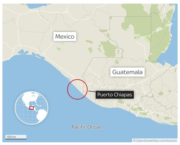
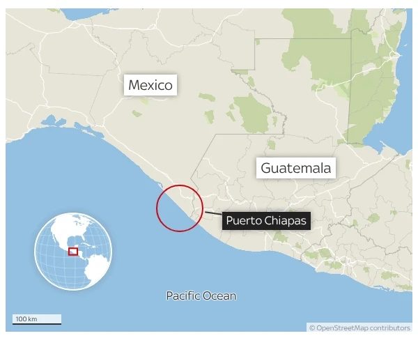
TAPACHULA, Chiapas, Mexico – July 17, 2026 – A formidable earthquake, registering a magnitude of 7.4, has rocked the Pacific coast of Mexico’s Chiapas state, prompting an immediate tsunami warning for coastal regions within a 300-kilometer radius of the epicenter. The powerful tremor, which struck at 17:39 local time on Friday, July 17, 2026, sent shockwaves across the region, causing widespread alarm and initiating emergency protocols from Mexican authorities.
The United States Geological Survey (USGS) reported the earthquake occurred at a relatively shallow depth of just 10 kilometers (approximately 6.2 miles), a factor that significantly amplifies its potential for destructive power and the generation of dangerous tsunami waves. Initial reports from eyewitnesses indicate the shaking was felt intensely across Chiapas and extended into neighboring Guatemala, where residents also experienced considerable ground motion. As authorities scramble to assess the full extent of the impact, the primary concern remains the potential for hazardous tsunami activity along the vulnerable coastlines.
Main Facts
The seismic event unfolded rapidly, plunging coastal communities into a state of heightened alert. The 7.4 magnitude earthquake, categorized as a major earthquake, is capable of causing significant damage to well-built structures and severe damage to poorly built ones, particularly near the epicenter. Its shallow depth is a critical parameter; shallow earthquakes tend to cause more intense shaking at the surface compared to deeper ones of similar magnitude, as the energy has less distance to dissipate before reaching populated areas.
The epicenter of the quake was located off the coast of Chiapas, a state in southern Mexico known for its rich biodiversity, indigenous cultures, and significant seismic activity due to its proximity to major tectonic plate boundaries. This particular region is part of the infamous Pacific Ring of Fire, a horseshoe-shaped belt of volcanoes and seismic activity that encircles the Pacific Ocean.
Following the initial seismic readings, the Pacific Tsunami Warning Center (PTWC) issued a bulletin advising of potential "dangerous waves" within 300 kilometers of the earthquake’s origin. This radius encompasses a significant stretch of the Mexican coastline, including major ports and tourist destinations, as well as parts of Guatemala and El Salvador. Such warnings are issued when an earthquake of sufficient magnitude and depth occurs in an ocean or coastal area, raising the possibility of a destructive tsunami. The term "dangerous waves" implies that coastal inundation, strong currents, and potentially life-threatening conditions could occur, necessitating immediate evacuation of low-lying areas. While the exact height of potential waves was not immediately specified, authorities urged residents to move to higher ground without delay.
Chronology of Events
The unfolding of the event has been swift, demanding rapid responses from emergency services and public information dissemination.
17:39 PM (Local Time), July 17, 2026: The 7.4 magnitude earthquake strikes off the coast of Chiapas, Mexico. Seismographs across the region and globally immediately register the powerful tremor.
17:45 PM – 18:00 PM: Initial reports from residents begin to flood social media and local emergency lines, describing intense shaking, objects falling from shelves, and widespread panic. The shaking is confirmed to have been felt strongly in cities across Chiapas, such as Tapachula, as well as in neighboring Guatemalan departments like San Marcos and Retalhuleu.
Approximately 18:05 PM: The United States Geological Survey (USGS) publishes preliminary data, confirming the earthquake’s magnitude, depth, and epicenter location, which are critical for subsequent tsunami risk assessments.
Approximately 18:15 PM: Based on the USGS data and its own monitoring, the Pacific Tsunami Warning Center (PTWC) issues a tsunami warning bulletin. This warning specifically highlights the potential for "dangerous waves" within a 300-kilometer radius of the epicenter, urging coastal communities to take immediate precautionary measures.
18:20 PM onwards: Mexican civil protection agencies, state authorities in Chiapas, and emergency services in Guatemala initiate their respective disaster response protocols. This includes:
- Issuing official public alerts via television, radio, and emergency siren systems.
- Activating evacuation plans for coastal areas identified as being at risk within the 300 km radius.
- Deploying emergency personnel to critical infrastructure points and vulnerable communities to assist with evacuations and damage assessment.
- Establishing emergency shelters for displaced residents.
- Continuous monitoring of sea levels via tide gauges to detect any anomalous wave activity indicative of a developing tsunami.
The initial hours following such an event are crucial, as tsunami waves can travel at speeds comparable to a jet airplane in deep ocean, though they slow down and grow in height as they approach shallow coastal waters. The 300-kilometer radius implies that the first waves could reach the nearest coastlines within minutes to an hour after the earthquake, making immediate response paramount. As of the latest updates, authorities continue to monitor the situation closely, emphasizing that the tsunami warning remains active until further assessment can confirm the absence of significant wave activity or the cessation of the threat.
Supporting Data and Context
Understanding the geological forces at play and the historical context is crucial for comprehending the gravity of this event.
Geological Background: A Region on Edge
Mexico, particularly its southern states, lies at the complex intersection of several major tectonic plates, making it one of the most seismically active regions globally. The Chiapas coast is situated above the subduction zone where the Cocos Plate is continuously diving beneath the North American Plate and the Caribbean Plate. This geological process, known as subduction, is responsible for creating deep ocean trenches, volcanic arcs, and frequent, powerful earthquakes.
The Cocos Plate is relatively young and dense, plunging beneath the lighter continental plates at a rate of several centimeters per year. This constant friction and stress build-up eventually release in the form of earthquakes. Shallow earthquakes, like the 7.4 magnitude event reported, often occur when the stress near the interface of these plates, closer to the surface, reaches a critical point and ruptures. This specific type of seismic activity is characteristic of subduction zones and is known to be capable of generating large-scale tsunamis.
The Pacific Ring of Fire, which encompasses Mexico’s western coast, accounts for approximately 90% of the world’s earthquakes and 81% of the world’s largest earthquakes. The historical record for this region includes numerous devastating tremors, serving as a constant reminder of its volatile nature.

Tsunami Mechanics: The Threat of "Dangerous Waves"
Tsunamis are not typical ocean waves caused by wind; rather, they are giant sea waves generated by large-scale disturbances of the ocean floor, most commonly powerful underwater earthquakes. When a shallow, high-magnitude earthquake occurs beneath the ocean, especially one with a significant vertical displacement of the seafloor, it displaces a massive column of water above it. This displaced water then generates a series of powerful waves that can travel across entire ocean basins.
The "dangerous waves" mentioned in the tsunami warning refer to the potential for these waves to cause significant inundation and destruction along coastlines. Unlike normal waves, tsunamis have extremely long wavelengths (often tens or hundreds of kilometers) and can travel at incredible speeds in the deep ocean, sometimes over 800 kilometers per hour (500 mph). As they approach shallower coastal waters, their speed decreases, but their height dramatically increases, sometimes reaching tens of meters. This can lead to rapid flooding, powerful currents capable of sweeping away structures and people, and the complete reshaping of coastal landscapes. The 300-kilometer radius specified in the warning indicates the immediate area where the first and potentially most impactful waves are expected to arrive earliest, necessitating swift action.
Regional Vulnerability and Preparedness
The coastal communities of Chiapas and Guatemala, while accustomed to seismic activity, remain highly vulnerable to the combined threats of earthquakes and tsunamis. Many areas are densely populated, with significant portions of the population living in low-lying coastal zones that are directly exposed to inundation. Infrastructure in some of these regions may not be fully resilient to major seismic events, particularly older buildings or those constructed without strict adherence to modern seismic codes.
Economically, these regions rely heavily on fishing, agriculture, and tourism. A significant earthquake and potential tsunami could cripple these sectors, leading to long-term economic hardship. The preparedness levels vary; while Mexico has invested in early warning systems and civil protection protocols following past disasters, the sheer scale of a 7.4 magnitude earthquake and its associated tsunami threat always tests the limits of these systems. Public awareness and adherence to evacuation orders are critical factors in minimizing casualties. Guatemala, also seismically active, faces similar challenges in terms of preparedness and the protection of its coastal populations.
Historical Precedents in Mexico and Central America
Mexico has a history marked by devastating earthquakes. The 1985 Mexico City earthquake, though centered hundreds of kilometers away in Michoacán, caused widespread destruction and thousands of fatalities in the capital due to the city’s unique geological makeup. More recently, the 2017 Chiapas earthquake (magnitude 8.2) and the Puebla earthquake (magnitude 7.1) caused significant damage and loss of life. While these were not primary tsunami-generating events on the scale of the current warning, they underscored the country’s vulnerability.
In Central America, the 1976 Guatemala earthquake (magnitude 7.5) devastated much of the country, killing over 23,000 people. While these historical events did not always involve significant tsunamis, they highlight the intense seismic potential of the region and the critical importance of robust emergency response and public education campaigns to mitigate future disasters. The current 7.4 quake, given its shallow depth and offshore location, aligns more closely with the conditions known to generate destructive tsunamis, such as the 2011 Tohoku earthquake in Japan or the 2004 Indian Ocean tsunami, although the scale of potential impact would vary based on specific local conditions.
Official Responses and Relief Efforts
The immediate aftermath of such a powerful event necessitates a coordinated and robust response from multiple governmental and international agencies.
Governmental Action: Mobilizing for Crisis
Upon confirmation of the earthquake and the subsequent tsunami warning, Mexican federal and state authorities immediately activated emergency response protocols. Mexico’s National Civil Protection System (Sistema Nacional de Protección Civil, SINAPROC) took the lead in coordinating efforts. This involved:

- Issuance of Public Alerts: Broadcasters, mobile phone networks, and social media platforms were utilized to disseminate urgent warnings to residents in coastal areas of Chiapas, Oaxaca, and Guerrero, urging them to seek higher ground.
- Activation of Emergency Operations Centers: Command centers were established to monitor the situation, coordinate rescue efforts, and manage resource allocation.
- Deployment of Emergency Personnel: Teams from the Mexican Army, Navy, National Guard, and local civil protection units were dispatched to vulnerable coastal zones to assist with evacuations, conduct initial damage assessments, and provide immediate aid.
- Opening of Temporary Shelters: Schools, community centers, and other sturdy buildings away from the coast were designated as temporary shelters for displaced residents, providing food, water, and medical assistance.
- Infrastructure Monitoring: Engineers and emergency crews began inspecting critical infrastructure, including roads, bridges, power grids, and communication networks, to identify and address any damage that could impede relief efforts or pose ongoing safety risks.
In Guatemala, where the quake was also strongly felt, the National Coordinator for Disaster Reduction (CONRED) similarly initiated its emergency plans, issuing warnings for its Pacific coast and advising residents to remain vigilant and follow local authority instructions.
International Cooperation: A Global Watch
The issuance of the tsunami warning highlights the vital role of international cooperation in disaster management. The Pacific Tsunami Warning Center (PTWC), based in Hawaii, is an operational center that monitors seismic activity globally and issues tsunami warnings and watches to countries around the Pacific Ocean. Their rapid assessment and communication are critical in providing lead time for coastal communities to prepare and evacuate.
Beyond the PTWC, other international bodies such as the United Nations Office for Disaster Risk Reduction (UNDRR) and various humanitarian organizations stand ready to offer support, resources, and expertise if the situation escalates or if Mexican and Guatemalan authorities request international assistance. This includes potential aid for search and rescue, medical supplies, and long-term recovery efforts.
Statements from Officials
While specific quotes were not immediately available, officials typically emphasize public safety and cooperation during such crises. A hypothetical statement from a Mexican Civil Protection official might articulate: "Our priority is the safety of our citizens. We urge everyone in coastal areas to heed the tsunami warning and move to higher ground immediately. Please follow the instructions of local authorities and emergency personnel. We are deploying all available resources to monitor the situation and provide assistance where needed."
Seismologists from institutions like the National Seismological Service of Mexico (SSN) would likely provide technical insights, explaining the nature of the earthquake and the ongoing risk of aftershocks. A statement might read: "This 7.4 magnitude earthquake is a significant event originating from the subduction zone. While we are continuously monitoring for aftershocks, the primary concern now is the potential for a tsunami. The shallow depth significantly increases this risk. Residents must remain vigilant and follow all evacuation orders until the threat has officially passed."
Potential Implications and Aftermath
The full scope of the earthquake’s impact, particularly concerning the tsunami threat, will unfold in the coming hours and days. However, potential implications can be anticipated based on the magnitude and location of the event.
Immediate Impact: Assessing Damage and Casualties
As of the immediate aftermath, there were no confirmed reports of casualties or widespread structural damage, but assessments are ongoing. The intensity of the shaking suggests that significant damage to buildings and infrastructure is probable, especially in communities closest to the epicenter. Landslides are also a common hazard following major earthquakes in mountainous or hilly regions, which could affect roads and isolated communities.
The most critical immediate concern remains the potential for the tsunami. If significant waves materialize, they could cause:

- Coastal Inundation: Flooding of low-lying areas, sweeping away homes, businesses, and personal property.
- Infrastructure Destruction: Damage to ports, docks, coastal roads, bridges, and essential services like water and electricity.
- Environmental Degradation: Salinization of agricultural lands, contamination of fresh water sources, and damage to fragile coastal ecosystems such as mangroves and coral reefs.
- Casualties: The primary risk to human life comes from the powerful currents and debris carried by tsunami waves.
Long-term Consequences: Economic and Social Disruption
Beyond the immediate crisis, the region could face substantial long-term challenges:
- Economic Disruption: Tourism, a vital industry for Chiapas, could suffer a severe blow. Fishing fleets and agricultural lands near the coast could be damaged or destroyed, impacting livelihoods. Rebuilding efforts will require significant financial investment and time, diverting resources from other development initiatives.
- Psychological Impact: Earthquakes and tsunamis are deeply traumatic events. Residents, particularly those directly affected, may experience prolonged psychological distress, anxiety, and post-traumatic stress disorder, requiring extensive mental health support.
- Displacement and Migration: Significant damage could lead to internal displacement of populations, as people seek safer areas or temporary housing, potentially straining resources in host communities. In extreme cases, it could even prompt longer-term migration.
- Infrastructure Repair and Resilience Building: The event will likely necessitate extensive repairs and, more importantly, a re-evaluation and enhancement of existing infrastructure to be more resilient against future seismic and tsunami events. This includes stricter building codes, improved early warning systems, and better evacuation routes.
Preparedness and Future Outlook: A Call for Vigilance
This earthquake serves as a stark reminder of the persistent seismic threat faced by Mexico and Central America. The rapid response of authorities and the adherence to early warning systems are crucial in mitigating loss of life. Continuous investment in advanced seismological monitoring, ocean-based tsunami detection buoys, and robust public education campaigns are paramount. Communities must regularly practice evacuation drills, and residents must understand the natural signs of a tsunami (e.g., a sudden recession of the sea) in case official warnings are delayed or unavailable.
As the situation unfolds, the world watches to see the full impact of this powerful natural event. The focus for now remains on ensuring the safety of all residents, assessing damage, and preparing for the potential aftermath of what could be a devastating combination of seismic activity and a subsequent tsunami. The resilience of the people of Chiapas and Guatemala will undoubtedly be tested in the coming days and weeks.
[END ARTICLE]