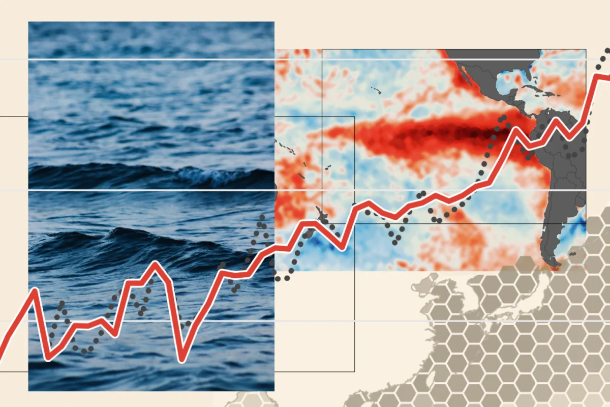
The global climate system is currently witnessing an extraordinary event as the 2026 "super El Niño" reaches unprecedented intensity. Characterized by a rapid and aggressive development that has outpaced all historical benchmarks, this naturally occurring climate phenomenon is fundamentally reshaping weather patterns across the globe. As sea surface temperatures in the tropical Pacific climb to levels never before recorded, the scientific community is grappling with the reality that we are entering a new, largely unpredictable phase of climate behavior.
Main Facts: A Statistical Anomaly
El Niño is a periodic fluctuation in winds and sea surface temperatures over the tropical eastern Pacific Ocean. It is defined by the Niño 3.4 anomaly—a measurement of how much warmer the surface waters in the central Pacific are compared to the long-term average.

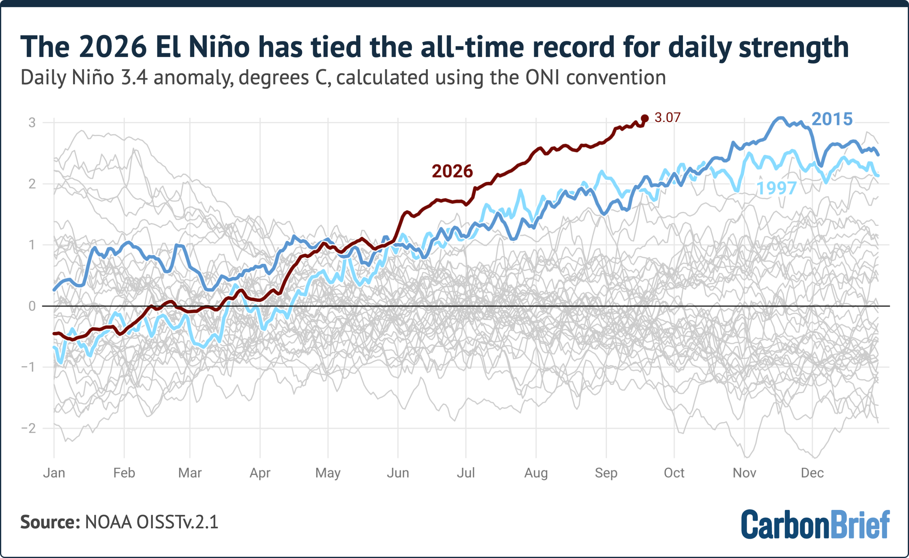
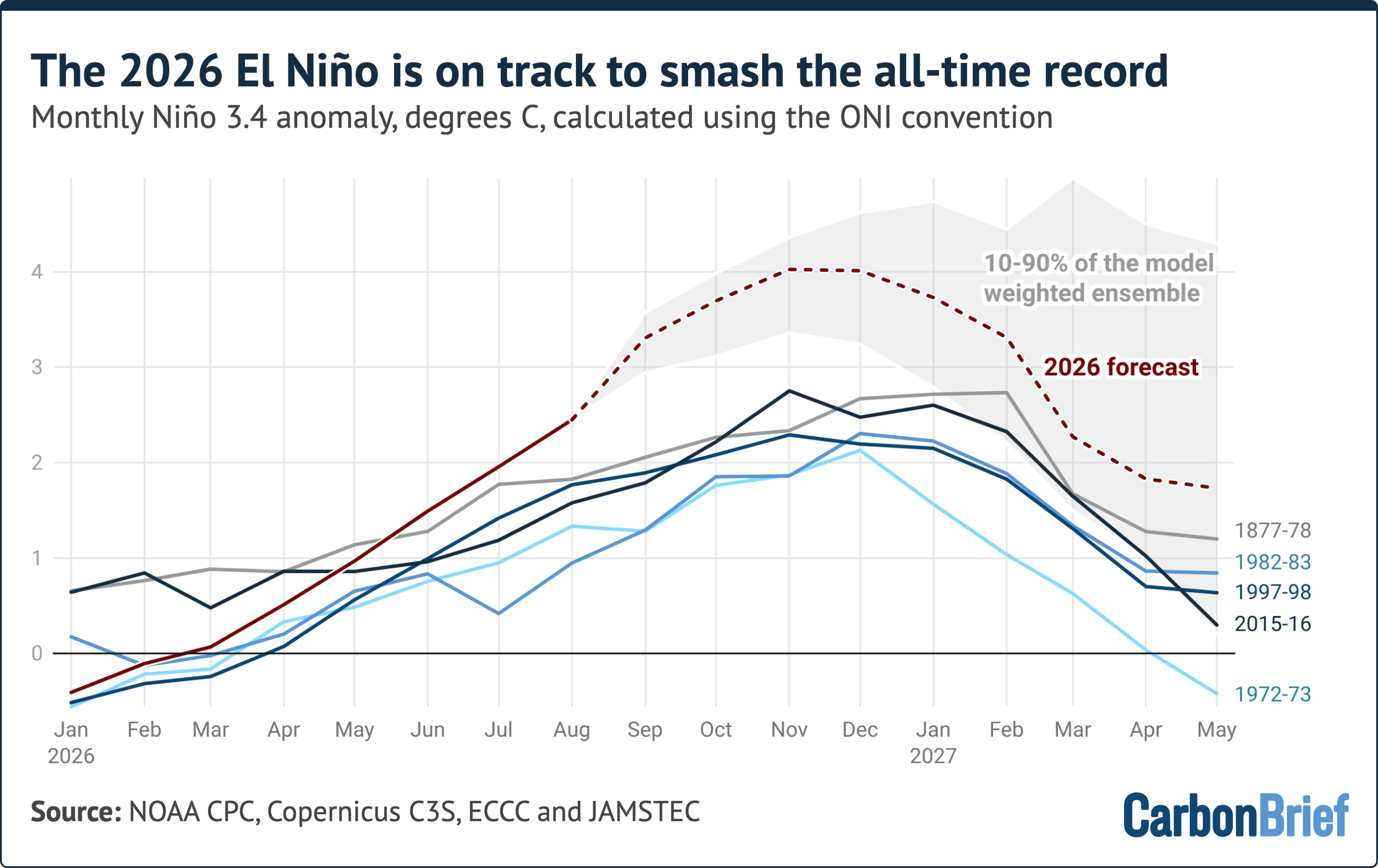
As of September 19, 2026, the daily anomaly in the Niño 3.4 region hit 3.07°C, placing it in a statistical dead heat with the previous record of 3.08°C, set in November 2015. However, while the 2015 record occurred at the typical peak of an El Niño cycle, the 2026 event is reaching these heights months earlier than expected. Many climate scientists, utilizing adjusted baselines for measuring these fluctuations, argue that the record has already been soundly broken.
The current event began its rapid ascent in June 2026 and has shown no signs of the stabilization typically expected at this stage. Because all strong El Niño events historically continue to intensify after mid-September, the meteorological community is bracing for a sustained period of record-shattering ocean warmth.
Chronology: A Rapid Development
The trajectory of the 2026 event has been nothing short of alarming. Unlike previous "very strong" El Niño years—such as 1997-98 and 2015-16—which followed a more predictable maturation cycle, the 2026 event began its surge with unprecedented velocity.
- June 2026: The onset of the phenomenon showed immediate signs of anomalous warming, outstripping the early-stage data of the most powerful historical events.
- August 2026: The monthly Niño 3.4 anomaly reached approximately 2.45°C. To put this in perspective, this value is higher than the peak of every prior El Niño on record, with the sole exception of the 2015-16 event and the historical 1877-78 reconstruction.
- Mid-September 2026: The daily anomaly hit 3.07°C, effectively tying the all-time daily record set during the height of the 2015 event.
- The Forecasted Peak: Current seasonal forecast models suggest that the event will continue to climb, potentially peaking between November 2026 and January 2027 at a staggering 4.1°C anomaly.
Supporting Data: Why This Event is Unique
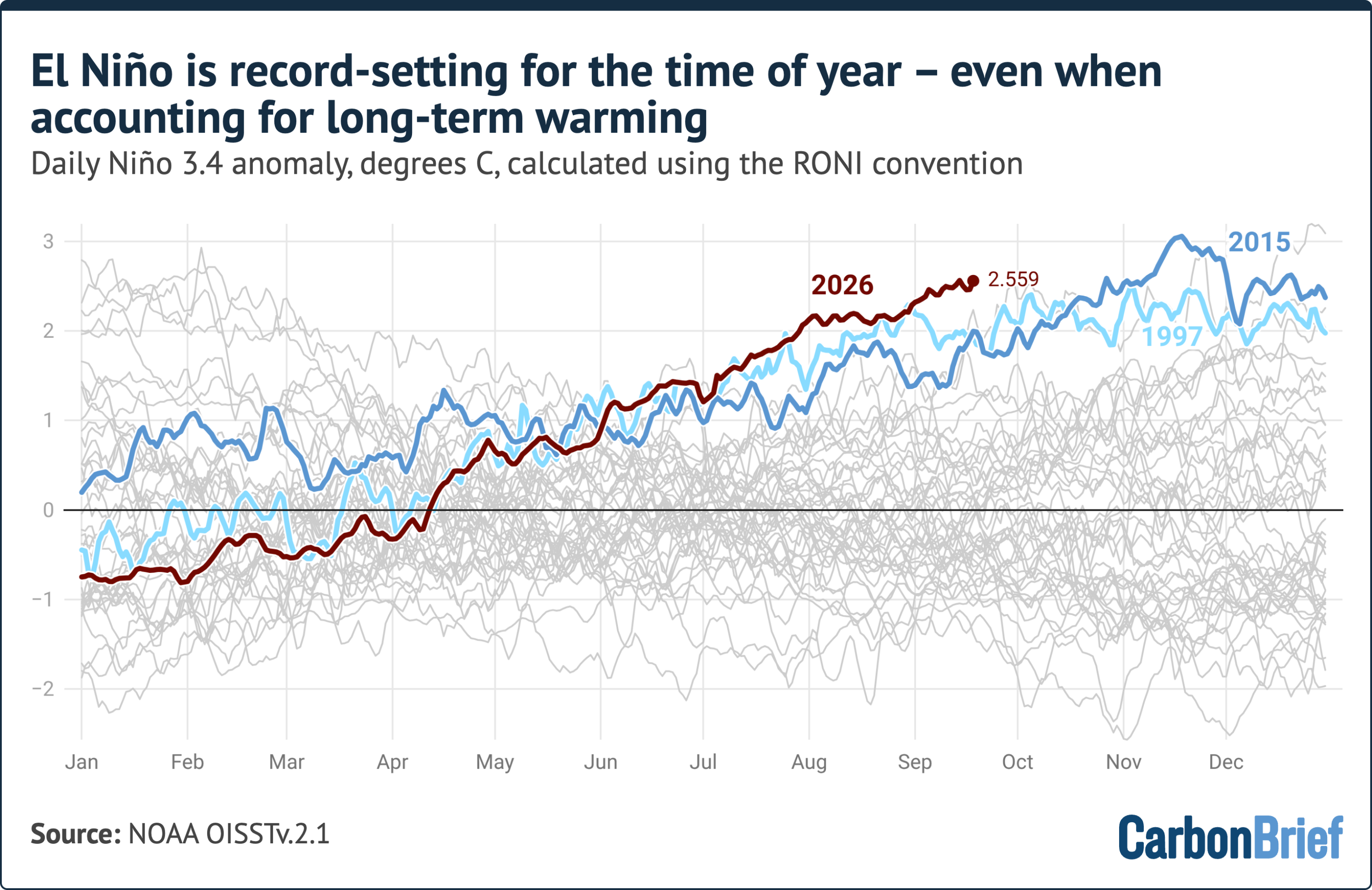
To understand the magnitude of this event, researchers utilize several indices. The primary tool is the Oceanic Niño Index (ONI), which subtracts the latest 30-year average temperature from current surface temperatures. This method is designed to isolate the El Niño signal from the long-term, human-induced warming of the planet. Even with this conservative approach, the 2026 event is rewriting the rulebook.
The RONI Perspective
An alternative metric, the Relative Oceanic Niño Index (RONI), was introduced by NOAA in 2024 to better account for tropical ocean warming linked to climate change. By subtracting the average temperature of the broader tropical oceans from the Niño 3.4 region, scientists hope to isolate the "pure" El Niño signal. While the 2026 event remains slightly below the 1982-83 record when measured by RONI, it is important to note that the 1982 record was achieved at the absolute peak of that winter. The 2026 event, by contrast, is still in its growth phase.
Model Consensus
Fourteen independent seasonal forecast models are currently in near-unanimous agreement: this event will surpass all previous records. Approximately 80% of the 674 individual model runs predict a peak anomaly between 3.4°C and 4.6°C. Such a projection would dwarf the 2015-16 record by a margin of 1.3°C—a gap larger than the entire difference between the first and fifth-strongest El Niño events of the last 150 years. While scientists acknowledge that models have occasionally overestimated summer temperatures, the current trend leaves little room for doubt regarding the event’s trajectory.
Official Responses and Scientific Caution
The global scientific community is exercising a degree of professional caution, acknowledging that we have never observed an event of this magnitude in the modern instrumental record. Because there is no historical precedent for a 4°C anomaly, our current climate models are operating in "uncharted territory."
Meteorological agencies are tracking the situation with heightened scrutiny, emphasizing that the primary concern is not just the temperature of the Pacific, but the lag effect. The impact of El Niño on global average temperatures is rarely instantaneous; the atmospheric response typically lags behind ocean warming by several months. Consequently, while 2026 is already on track to be one of the warmest years in human history, the most severe climate consequences of this super El Niño are expected to be felt throughout 2027.

Implications: A World in Flux
The implications of a super El Niño are vast, impacting everything from agricultural stability to wildfire risks and human health.
Wildfires and Emissions
One of the most immediate and tangible consequences of the current El Niño is the increased risk of uncontrolled wildfires. In regions like Indonesia, the climate pattern is already driving record-breaking fire emissions. The dry, hot conditions induced by the shifting weather patterns turn peatlands and forests into tinderboxes, resulting in massive releases of stored carbon into the atmosphere, which in turn acts as a feedback loop for further warming.
Global Weather Shifts
The "super El Niño" is essentially a re-plumbing of the global atmosphere. By shifting the location of tropical rainfall, it alters the path of the jet streams. This can lead to:
- Drought in the West Pacific: Australia, Southeast Asia, and parts of Africa face severe moisture deficits, impacting crop yields and water security.
- Extreme Precipitation in the Americas: Regions of the southern United States and parts of South America often experience increased storm activity, flooding, and infrastructure strain.
- Temperature Spikes: Because El Niño releases massive amounts of heat from the ocean into the atmosphere, the world should prepare for a series of record-breaking monthly global temperature averages in the coming year.
Long-term Outlook
As we look toward 2027, the focus shifts from the ocean to the atmosphere. The "state of the climate" analysis conducted by researchers at Carbon Brief and other institutions underscores that we are in a transition period. The 2026 record is not an isolated incident; it is a manifestation of how climate change interacts with natural variability. When a super El Niño occurs against a backdrop of a planet already warming due to greenhouse gas emissions, the results are exponentially more severe than in previous decades.

In summary, the 2026 super El Niño is not merely a record-breaker; it is a test of our global resilience. As the anomaly continues to climb, the international community must prepare for a period of extreme weather volatility that will challenge agricultural systems, emergency management, and global climate policy. The coming months will be critical, as the world waits to see just how high the temperatures will go and what the long-term footprint of this event will be on our changing planet.