
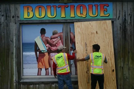
As the sun began to set on the Gulf of Mexico this Friday, the horizon darkened not just with the arrival of dusk, but with the encroaching wall of Hurricane Isaias. A formidable Category 2 storm, Isaias is barreling toward the US Gulf Coast, marking a dramatic and volatile conclusion to what has been an anomalously quiet 2026 Atlantic hurricane season. With landfall expected along the western Florida Panhandle by late Friday night, local, state, and federal authorities have mobilized for what officials are calling a "life-threatening" event.
Emergency declarations are now in effect across Alabama, Florida, and Mississippi as residents scramble to complete final preparations. The National Hurricane Center (NHC) has warned that the storm, while not expected to hit at its peak intensity, remains a potent threat capable of causing catastrophic damage.
The Anatomy of the Threat: Winds, Surges, and Rainfall
Hurricane Isaias presents a trifecta of hazards for the coastal regions in its path. As of Friday evening, the storm was churning approximately 45 miles south of Pensacola, Florida, maintaining maximum sustained winds of 110 mph. While this is a slight decline from the 120 mph recorded earlier in the day, the sheer scale of the storm’s impact remains unchanged.
The most immediate danger cited by meteorologists is the "life-threatening storm surge." Projections indicate that sea levels could rise by as much as 7 feet (2.1 meters) in vulnerable areas like Dauphin Island, Alabama, and Indian Pass, Florida. When combined with the estimated 30-foot wave heights, the potential for coastal inundation is severe.
The National Weather Service (NWS) has taken the extraordinary step of issuing an "extreme wind warning" for the western Florida Panhandle. In a stark social media advisory, the NWS office in Mobile, Alabama, commanded residents to seek shelter immediately. "Treat these imminent extreme winds as if a tornado was approaching and move immediately to an interior room or shelter NOW!" the agency urged.
Beyond the wind and surge, Isaias is expected to act as a massive rainfall engine. Forecasters anticipate up to 15 inches (380mm) of precipitation in some coastal zones, significantly increasing the risk of flash flooding. Furthermore, the outer bands of the hurricane are primed to spawn tornadoes from Alabama through the Florida Panhandle and into southwestern Georgia throughout the night and into Saturday morning.

A Rare Late-Season Anomaly
The emergence of Isaias is historically significant. The 2026 Atlantic hurricane season had been remarkably subdued, largely due to a persistent and strong El Niño event, which typically creates wind shear that disrupts tropical storm formation. Before Isaias, the Atlantic had not seen its first hurricane this late in the calendar year since October 8, 1905.
Because this development predates the modern satellite era, meteorologists are navigating a somewhat unfamiliar landscape. The lack of previous late-season benchmarks means that current infrastructure and emergency response systems are being tested against a scenario that has not occurred in over 120 years.
Chronology of the Crisis
The escalation of Isaias from a tropical disturbance to a hurricane was swift, catching many by surprise given the season’s previous lethargy.
- Early Week: The system was identified in the Gulf of Mexico, with climate models showing a rapid intensification path toward the Florida Panhandle.
- Wednesday: As the storm organized, energy companies began precautionary measures, initiating the shutdown of offshore oil and gas platforms.
- Thursday: Governor Kay Ivey of Alabama ordered mandatory evacuations for non-residents in high-risk zones like Gulf Shores and Orange Beach. Simultaneously, state of emergency declarations were signed across 40 Alabama counties, 27 Florida counties, and several jurisdictions in Mississippi.
- Friday Morning: Coastal areas began experiencing the first signs of the storm, with heavy rain and tropical-storm-force winds moving onshore. Traffic congestion clogged highways as residents attempted to move inland.
- Friday Evening: The NHC confirmed the storm was approximately 45 miles south of Pensacola, moving north at 18 mph. The window for physical preparations effectively closed as the storm began its final approach to the coast.
Economic and Industrial Impacts
The Gulf Coast is the heart of the American energy sector, and the arrival of Isaias has had an immediate, tangible impact on national production. According to the Marine Minerals Administration, the industry has been forced to halt nearly 63% of offshore oil production in the region.
This disruption accounts for approximately 1.3 million barrels of crude oil taken off the daily market. With 121 out of 371 crewed oil platforms evacuated, the logistical challenge of restarting these operations post-storm will be significant, potentially leading to a temporary spike in energy costs and supply chain bottlenecks.
Official Responses and Federal Preparedness
The political response has been robust, with state governors deploying the National Guard to assist in potential search-and-rescue operations. In Florida, Governor Ron DeSantis confirmed that 5,000 National Guard troops have been mobilized, while local school districts have shuttered classrooms to ensure student safety.
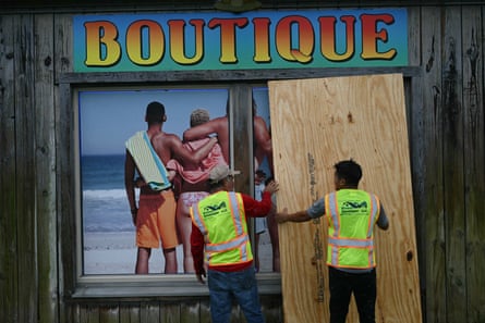
However, the storm arrives at a time of deep anxiety regarding the readiness of the Federal Emergency Management Agency (FEMA). Experts have labeled Isaias the "first major test" for the agency following the extensive budget cuts and restructuring initiatives implemented by the Trump administration.
A recent report from the US Government Accountability Office (GAO) underscored these concerns, noting that the agency lost over 4,300 employees—roughly 17% of its workforce—during fiscal year 2025. Chris Currie, director of homeland security and justice at the GAO, testified that these reductions were not executed with a clear plan to maintain the agency’s statutory obligations. As the administration pushes for states to shoulder more of the financial and logistical burden of disaster relief, the performance of FEMA during Isaias will likely be scrutinized as a bellwether for the federal government’s future disaster management capacity.
Implications for the Future
As the rain lashes the Florida coast and the winds howl across the Panhandle, the immediate priority remains the preservation of life. Residents have been warned to prepare for long-duration power outages, as the combination of saturated soil and high winds will likely topple power lines and grid infrastructure.
Looking beyond the current crisis, the arrival of Isaias serves as a sobering reminder of the volatility of the modern climate. While El Niño provided a temporary reprieve, the ability of the Atlantic to produce a high-intensity hurricane in October highlights that the "hurricane season" is a fluid concept.
The coming days will be defined by the success of evacuation efforts, the resilience of regional power grids, and the effectiveness of the emergency response. As the storm makes landfall and begins its expected weakening trend, the focus will shift from mitigation to recovery—a process that will undoubtedly bring the debate over FEMA’s capacity and the federal government’s role in climate-driven disasters to the forefront of the national conversation.
For the people of Alabama and Florida, the night ahead is one of endurance. For the rest of the nation, Isaias stands as a potent warning that even a quiet season can end in a roar, demanding readiness that neither policy shifts nor historical trends can provide.