
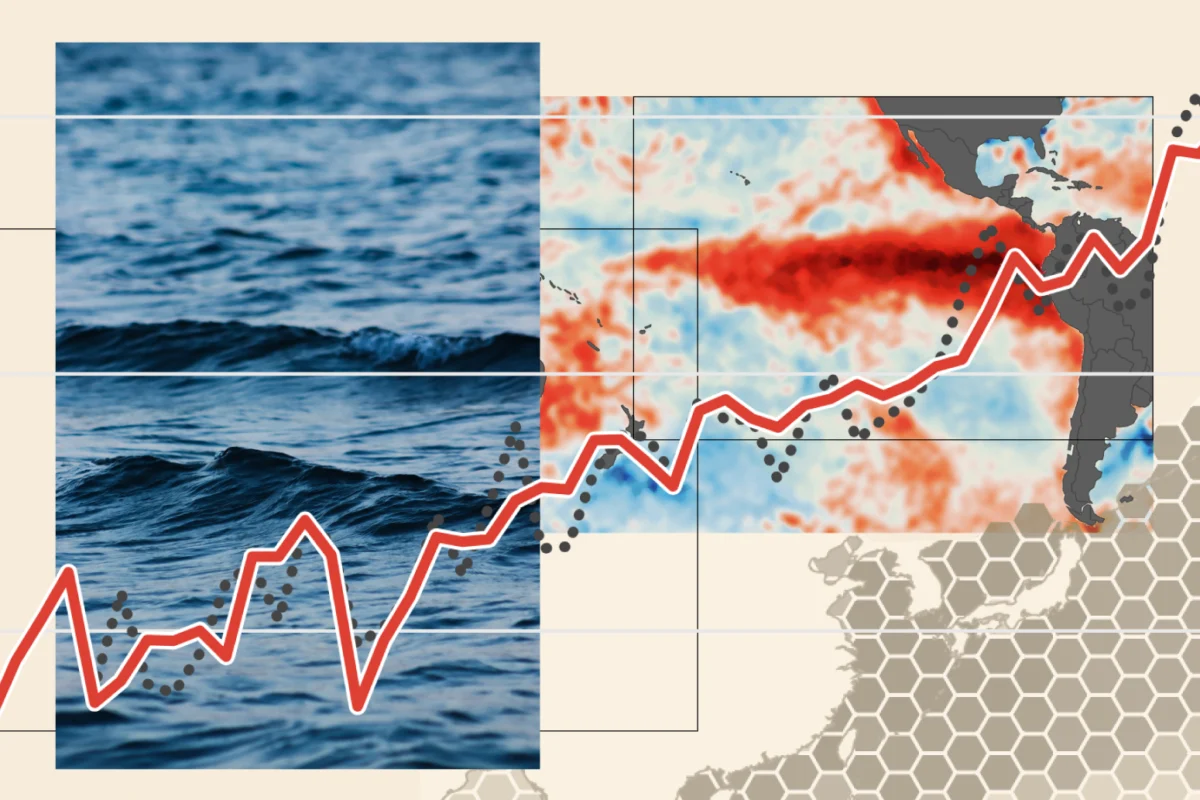
The Earth’s climate system is currently witnessing a historic shift. The ongoing "Super El Niño," a naturally occurring climate phenomenon centered in the tropical Pacific, has officially shattered previous intensity records, signaling a period of unprecedented thermal anomalies. As of late September 2026, sea surface temperatures in the critical Niño 3.4 region have climbed to levels never before documented in the modern instrumental record, forcing meteorologists and climate scientists to recalibrate their understanding of the event’s trajectory and potential impact.
The Core Data: Breaking the 2015 Benchmark
El Niño is defined by a warming of the central and eastern Pacific Ocean, a process that inherently reshapes global weather patterns and provides a temporary, yet significant, boost to global average temperatures. The current event, which began its rapid development in June, has moved at a pace that has left previous records in the dust.

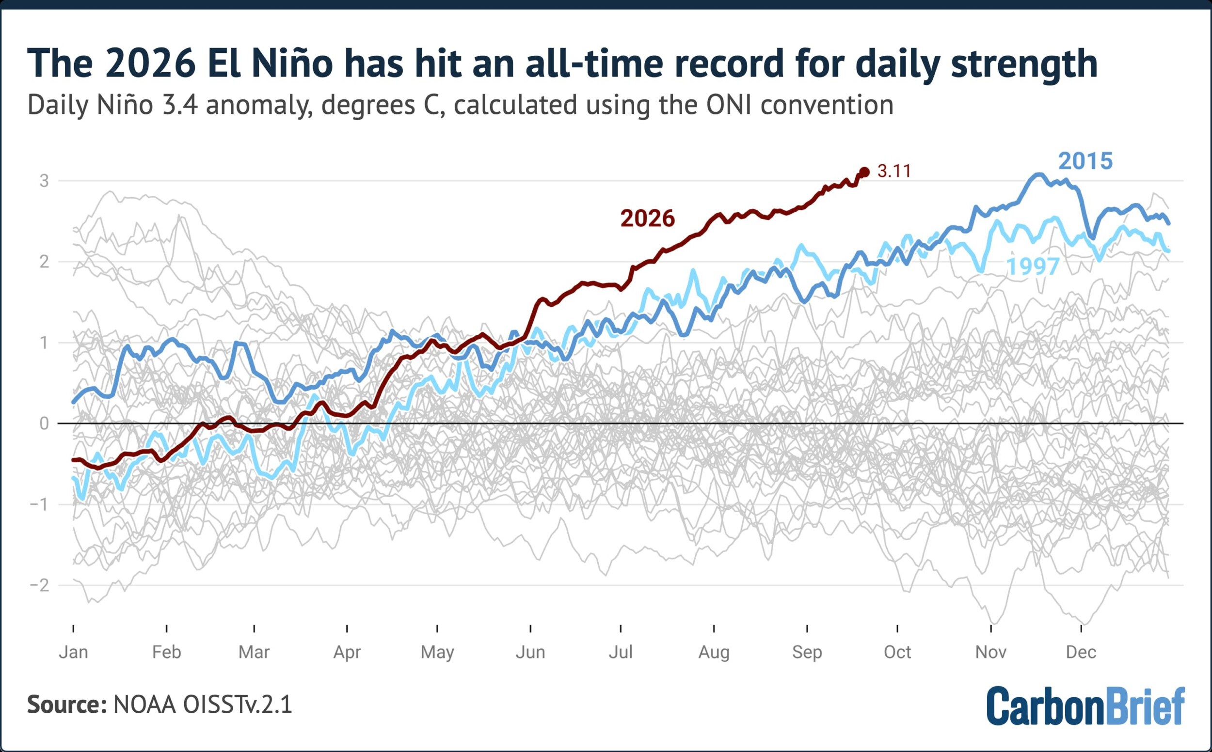
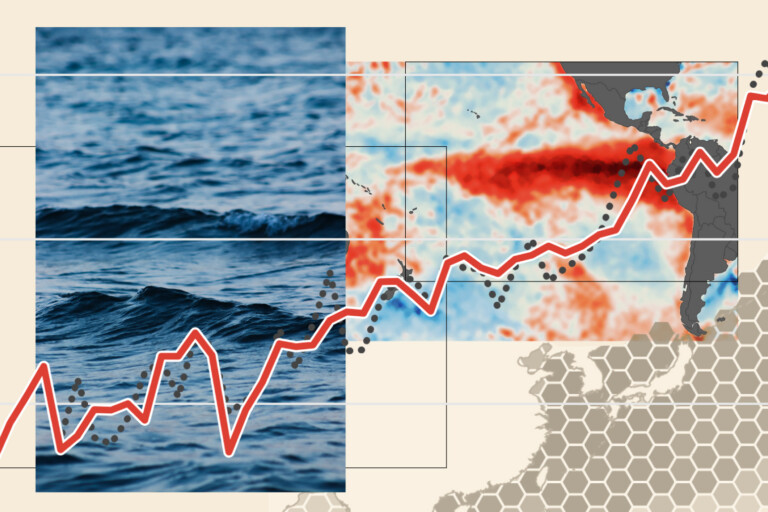
The primary metric for tracking this intensity is the "Niño 3.4 anomaly," which measures the temperature variance from the long-term average in a specific section of the tropical Pacific. On September 21, 2026, the daily anomaly reached a staggering 3.11°C, officially surpassing the previous record of 3.08°C set on November 18, 2015—a year synonymous with one of the most powerful El Niño events in recorded history.
What makes this surge particularly alarming is its timing. El Niño events typically reach their peak intensity during the Northern Hemisphere winter months, most commonly in November or December. The fact that the 2026 event has reached such extreme levels as early as September suggests that the phenomenon is not only intense but is exhibiting a sustained, aggressive development phase. Every significant "strong" El Niño recorded in history has continued to intensify beyond mid-September; consequently, there is little reason to believe the current upward trend will plateau before reaching its climactic peak later this year.
Chronology of a Climate Outlier
To understand the severity of the current situation, one must look at the timeline of development.
- June 2026: The onset of the current El Niño began with a rapid acceleration that caught many seasonal forecasters by surprise.
- Early September 2026: As the event gained momentum, scientists noted that anomalies were already hovering at 1.9°C—a figure that, in both 1997 and 2015, was not reached until significantly later in the season.
- September 21, 2026: The official crossover point. The daily anomaly surpassed the 2015 record, marking a new, sobering milestone in modern meteorology.
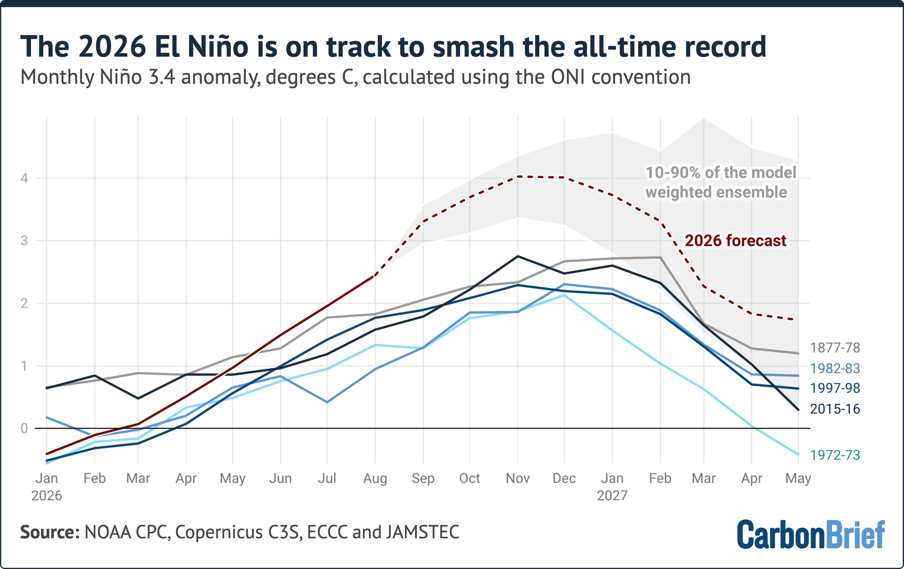
- The Forecast (Late 2026 – Early 2027): Seasonal models now project a peak monthly anomaly of approximately 4.1°C. While caution is required—as no model has ever been tested against an event of this magnitude—the consensus among 14 major seasonal forecast models is unanimous: the 2026 event is on a trajectory to dwarf all previous historical observations.
Supporting Data and Methodological Nuance
Scientists utilize various indices to track these anomalies, each offering a different perspective on the event’s strength. The Oceanic Niño Index (ONI), used by the US National Oceanic and Atmospheric Administration (NOAA), subtracts the latest 30-year average temperature to provide a relative comparison. This method is crucial because it helps filter out the long-term, human-induced warming trends that have shifted the baseline of global ocean temperatures.
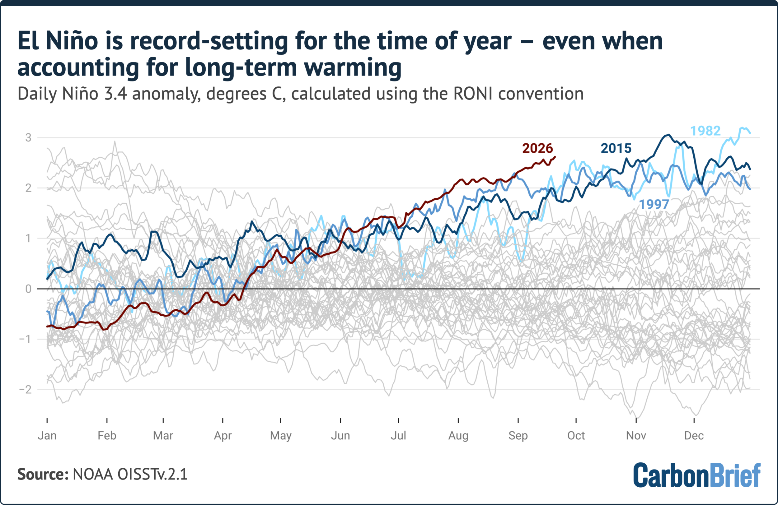
However, researchers also employ the Relative Oceanic Niño Index (RONI). Introduced by NOAA in 2024, the RONI attempts to isolate the El Niño signal by subtracting the temperature anomalies observed across the broader tropical ocean (20°N to 20°S). While this provides a more nuanced view of the phenomenon, it can occasionally diminish the perceived strength of events that span vast geographic areas. Even under the more conservative lens of the RONI, the 2026 event is showing record-setting values for this time of year, trailing only the 1982-83 event, which reached its peak in December.
The data confirms that we are not merely seeing a "strong" event; we are seeing an event that behaves differently than its predecessors. The gap between the 2026 anomaly and previous records is expanding, with the current projected peak (4.1°C) being more than 1.3°C higher than the 2015-16 record. This margin is larger than the entire spread between the first and fifth strongest El Niño events of the last 150 years.
Scientific and Official Perspectives
The global scientific community is responding with a mix of academic rigor and urgent caution. Experts emphasize that because an event of this intensity is unprecedented in the era of satellite observations, there is a degree of uncertainty regarding how the atmosphere will respond.
Meteorological organizations are currently grappling with the reality that historical models, while highly advanced, are essentially being "stress-tested" by the current data. The fact that real-world observations this summer were slightly lower than some high-end forecasts (by roughly 0.3°C) serves as a reminder of the inherent volatility in seasonal climate prediction. However, the unanimity of current models regarding the winter peak provides a compelling, if worrying, outlook.

The implications of this data extend beyond the ocean. International agencies are already monitoring the secondary effects, such as increased wildfire risks in regions like Indonesia, where the drying effect of El Niño is historically correlated with massive carbon emissions from peatland and forest fires.
Broader Implications: A Warmer World
The ramifications of a record-breaking Super El Niño are profound and global. It is important to note that the impact of El Niño on global temperatures typically lags behind the physical heating of the Pacific ocean by several months. Consequently, while 2026 is already on track to be one of the warmest years on record, the most acute impacts of this current event are expected to be felt in 2027.
The 2027 Outlook
The scientific community is currently pivoting its focus toward 2027. If the current El Niño persists and peaks at the projected levels, the global climate will likely experience a significant temperature spike. This has led to intense scrutiny of what this means for global agricultural stability, water security, and ecosystem health.
Climate Change Synergy
One of the most pressing questions for researchers is how this Super El Niño interacts with the background signal of anthropogenic global warming. The current event is occurring in an ocean that is, on average, warmer than it was during the 1997 or 2015 events. This "supercharging" effect suggests that we are entering a new phase of climate variability, where natural oscillations interact with a heated baseline to produce extremes that were previously thought to be statistical impossibilities.

Policy and Preparedness
For policymakers, the data serves as a wake-up call. The necessity for resilient infrastructure, robust early-warning systems, and proactive disaster management has never been greater. As the world prepares for the potential impacts of this event—ranging from shifts in precipitation patterns that could trigger floods in some regions and droughts in others—the scientific data provided by these indices is the primary tool for saving lives and protecting livelihoods.
Conclusion
The 2026 Super El Niño is a definitive event in the history of climate science. By every available metric, it is pushing the boundaries of what has been observed since records began. As we approach the winter months, the world watches the tropical Pacific with a sense of historic gravity. Whether this event marks a temporary outlier or a new, more intense "normal" in a warming world remains the central question for the climate scientists of the coming decade. What is certain, however, is that the data recorded in the coming months will be studied for generations, serving as the benchmark by which all future climate anomalies will be measured.